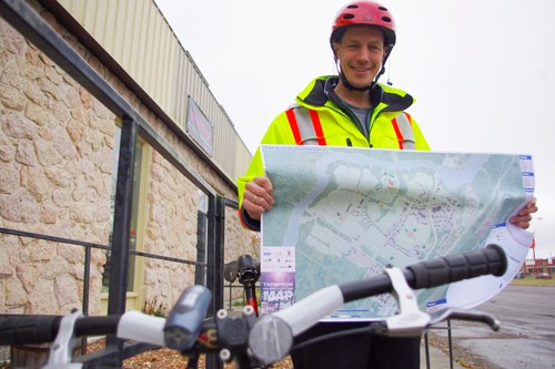
Plot your course for a trip using two feet and a heartbeat with the Thompson walking and cycling map now available at various locations around town and from the Northern Regional Health Authority (NRHA) website.
Unlike a road map, this version shows sidewalks and both formal and informal paths darker than the roads, emphasizing the options Thompson offers for getting around without spending money on gas, says Bruce Krentz, a regional health promotion co-ordinator with the NRHA and a year-round cycle commuter as well as one of the many people and organizations that contributed to the production of the map.
“People outside realize it was well-planned for cycling,” Krentz says of Thompson, pointing out that active transportation advocate Anders Swanson of Winnipeg, who’s biked around the city on visits here before, was one of the driving forces behind the map’s development. “He did the computer graphics part of it,” says Krentz, and then reviewed it with people from Thompson to ensure that it was accurate.
The maps are available at most of Thompson’s hotels, as well as the train station and bus depot, City Hall, the Thompson Regional Community Centre and the Heritage North Museum. The city and the museum were among the organizations that helped to produce the map, with printing of the first run of 5,000 copies paid for by the NRHA and a grant from In Motion, a provincial strategy to promote physical activity as part of Manitobans’ their daily lives. A PDF of the map is also available from download from the publications section of the NRHA website.
Part of the motivation for the map is to show people that Thompson’s roads are often not the most efficient way to get around and to highlight areas that people may not think of as walking areas, like schoolyards, that make a walk or bike across the city that much faster.
Not all the paths indicated on the map are paved, or even official, with informal paths – what active transport planners call desire lines – shown by dotted lines, to signal that they may be uneven or muddy to people using the map.
“We didn’t want to not put them on the map,” Krentz says, though not all users may wish to take advantage of them.
The map also serves as a guide for the city to see where pedestrian infrastructure like sidewalks are lacking.
“It’s a pretty good planning tool,” says Krentz.
It also helps newcomers from places where walking is more common see how to get around and parents with kids in school how convenient it generally is to get to any of Thompson’s six elementary schools.
Included on the map is the Millennium Trail, which can be used for commuting or cycling by foot or bike in an environment generally free of vehicle traffic, but isn’t always well-marked.
“There isn’t a good map of the Millennium Trail right now,” Krentz says.
Future plans to get the map into the hands of residents include having the Juniper Centre deliver copies to every household in Thompson, a plan that was delayed to ensure the map wouldn’t get recycled during election season when people may be swamped by more flyers than usual. That distribution may not take place until the spring when people are more likely to think about walking or cycling where they’re going, though Krentz says the window for pedestrian and cyclist commuting is much longer than people think, even if they aren’t committed enough to try it through the winter.
“September and October are great for cycling,” Krentz says.


